
|
I headed out the Omagh road in Co. Tyrone along one of my favourite storm chasing locations where the vast open sky and huge expanse of beautiful countryside lends itself perfectly for thunderstorm photography. This was one of my early afternoon target areas before plan B came into effect later in the afternoon. The Sun was shinning, it felt warm and very humid, exactly like what a thunderstorm day should feel like. My plan was to meet chaser Paul Martin then spend the day on the road together, however as I scanned the skies I knew the day wasn't going to reveal its secrets so soon. The convection was capped and of low vertical extent and to the untrained eye it looked like a bust chase day. However I knew from the feel of the air and the synoptic set-up that this day had a lot of potential, this was what we called a loaded gun scenario when the capping inversion kept a lid on the increasingly building energy, when it broke storms could be explosive, then it was just a matter of being in the rite place at the rite time.
I pulled into the layby at Drum Manor Forest Park and got out to enjoy the sunshine in the company of towering cumulus and Cherry Blossom trees. Paul was as pumped as I was, he said he had a good feeling about this day, when Paul says this then you can be rest assured its going to be an interesting day, I admitted that I also had a good feeling too and to complete the positive vibes I put on my lucky baseball cap. The outlook promised the greatest instability of the season with more than 1000j/kg of CAPE in a SWly humid air mass with soundings showing -50c cloud tops overlapped by 20 knots of deep layer shear which promised organized multicell thunderstorms. With a small temperature-dew point spread cloud bases were expected to be low and with several convergence zones forming to the NE and E of Lough Neagh it looked like we had the potential for funnel clouds or even weak tornadoes.
Despite being a post-frontal air mass this was actually a classic Summer warm sector set-up and adding to the dynamics was a cold front approaching from the W during the evening hours. Models indicated random discrete cells near the Sperrins and Co. Tyrone then the area of interest shifting to the Lough Neagh basin with evening developments focused over Co. Antrim and Co. Down. Our plan was to start W then shift NE as the day went on and that was exactly what we were doing now. Paul and I agreed that the sky was unimpressive at our location and the vibes were not good here, however to our far N/NE we could see towers getting taller in the Maghera region which began to get our attention.
I received a text from convective forecaster Owain Rice informing us that the NE of the lough was a forming convergence line with a large red signature on radar already so this looked like the place to be. Paul and I agreed to chase to Maghera, re-evaluate the situation, then hunt NE into the convergence zone. We began making our way in that direction with both of our vehicles making a bee line for a target area which we hoped would bare atmospheric fruit. With storm chasing it's always a gamble, you rely on evidence, cloud observation, radar, knowledge of the parameters but more often than not you are driven by instinct. Decision making is very important but once you make that decision you have to stay committed to the area because if you end up chasing your tail back and forth all over the country then you are in for a bad panicky day which isn't fun at all, having target fixation can be a good thing.
Our original plan to meet at Maghera changed rather quickly, as we passed through Moneymore we could see huge towers to the NE from the best cell in the country which seemed to have appeared from nowhere, this was clearly the focus of convective initiation, we pulled over outside Desertmartin for a brain storm. Radar confirmed a huge red core to the E of Ballymena moving NE, so we gave chase in that general direction, so off we went again through Maghera and Gulladuff. As we navigated the back roads we got teasing glimpses of the cell when we crested hills, this was clearly a beautiful white sunlit multicell with big anvil sheared to the NE towards the coast and a flanking line of back building towers. The base was well defined and low to the ground with areas of dramatic white scud under the base, we really wanted to get closer however the cell moved further away towards the NE coast, it was impossible to keep up with so we let it go and pulled over for a new plan.
We decided we needed some energy so a food break was in order, the mind thinks better when its not tired. We also made the wise decision that we where in a good area, we reasoned that with this being a convergence zone then chances were good another cell could form here later with the same result so at least we where in a very strategic position. Meanwhile we drove into Portglenone to the local shop to get snacks and drinks, it was there that we literally walked into Portglenone chaser Colleen Webb who was just finishing work and eager to get out chasing. We grabbed our snacks then on Colleen's suggestion we re-located to a country road on high ground to the W of Ballymena, a location where I had scored two thunderstorms in previous years so with our three vehicles we pulled in, ate, and settled in for a game of patience.
 |
Eventually we got rewarded when a cell formed to the W and began creeping towards our general direction. It took on the form of a line with a subtle shelf cloud, I got the Mavic 3 Classic up for it's first flight of the day. Drone 80m high facing W to what looked like a developing storm, things were getting interesting, tensions were high as we all wondered if we had made the correct decision to stay at this location. Then the cell weakened, it's structure dissolved and it did nothing as it passed over, just a light shower of rain, our hopes were dashed and our excitement took a major dip.
It was already late afternoon and the sky looked completely capped and dead, the clouds were short with no life at all. I will confess that at this point I lost all my motivation and positivity. It looked like a complete bust, how could the synoptics be wrong?, how could all the convective experts be so wrong also? the cap was supposed to break early in the day but it never did. This was shaping up to be a spectacular let-down after such an exciting build-up the night before. A storm bust is hard enough, but it's even worse when you have to drive all the way home with nothing to show for it, those who don't chase are unaware of this emotional roller coaster ride. Just the day before Roisin and I drove five hours around the Sperrins waiting for storms to fire which they never did, that was another cap bust (except Lough Foyle and Donegal), when you come home exhausted from driving all day, eyes sore from looking at clouds and the sun and the expense of fuel and food then it really takes its toll on you mentally.
The thought of going home this day empty handed with no images was unacceptable to me, I made the decision to stick it out as long as I could until all chances were gone, Paul and Colleen felt the exact same way, we were regimental with our mind-set. Then Nigel McFarland arrived, he had just finished work and had made the drive to our location from the north coast with the intention of chasing so now we had four vehicles at the road side with occupants scanning the skies, which a this stage still looked hopeless, I hoped that Nigel hadn't come all this way for nothing, however his attitude was positive and confident, ''it's a day out'' he said, and I fully agreed, storm chasing is a road trip and an adventure and should be enjoyed no matter what the outcome and even more so when friends get to meet up on the country roads.
We brain stormed again, in all fairness the AROME had been fairly accurate all day with it's location of cells and showers, we checked the latest, it showed strong cores over our exact location around 19.00 and another very strong core SW of the Lough at 20.00. So that was something at least, our new basic plan was to get that cell here then shoot to the lough for the last chance of the day. But the seeds of doubt were still in the air, what if the cells died by the time they got here? maybe the waning solar heating and weakening CAPE would be gone by then? should we just go to the lough now and wait it out? the temptation was strong to drive off somewhere else, maybe back W/SW but for some reason we couldn't move, Colleen said she had a feeling we should stay where we are.
We contacted forecaster Owain Rice and asked his advise, he too was surprised by the cap not breaking but as we chatted things were already happening. It looked like the cap was breaking in the W, red cores had formed over the Sperrins ahead of the advancing cold front, the front acted like a source of lift and the cooler upper air was eroding the warm mid levels, sparks where plotted over Strabane and soon a multicell cluster/line had formed moving SW to NE, finally our long wait was paying off. We still faced the same dilemma however, should we stay put and risk it all falling apart or chase back W and intercept the line?. I asked Owain what he thought, he quoted a line from US storm chaser Pecos Hank which said ''if you don't know where to go, then go nowhere'', I thought this was brilliant, it was also a good omen so we took Owain's advise and remained on location.
 |
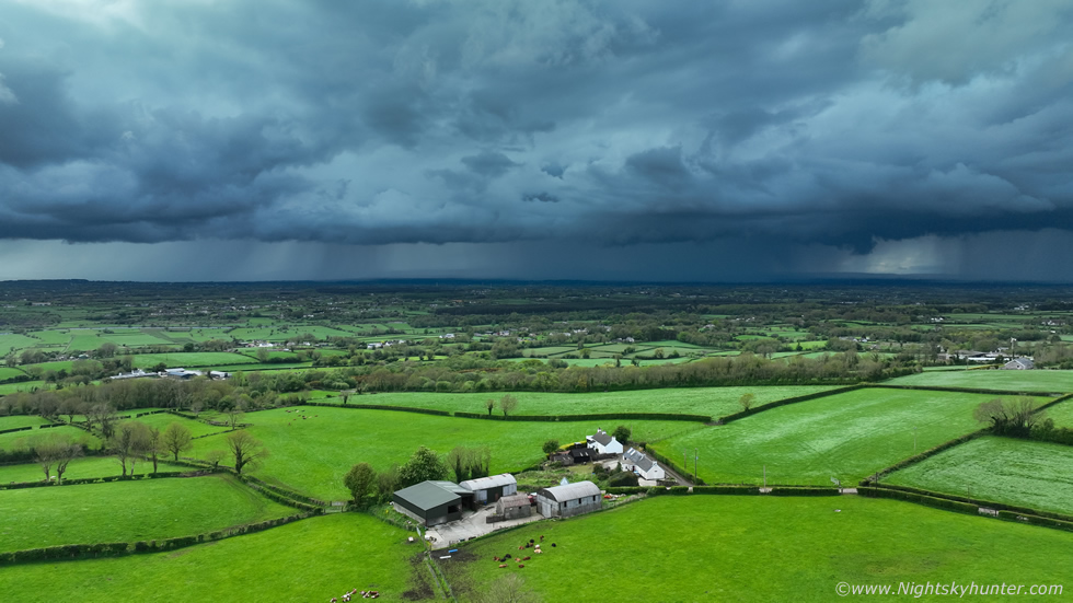
Miles away to our W the sky was darkening, we could see a long wall of moody cloud and a precipitation core which was getting larger with every passing minute. Another radar checked showed a line of red cores extending all the way from Co. Tyrone to the Co. Antrim coast, reports on social media were showing a shelf cloud over the sea. We could hear distant rumbles barely perceptible to the ear however after a period of time it became very obvious this was thunder rumbling from somewhere off in the distance. This was our first visual sign that was something was inbound, even though the base was hidden behind the tops of the Sperrins.
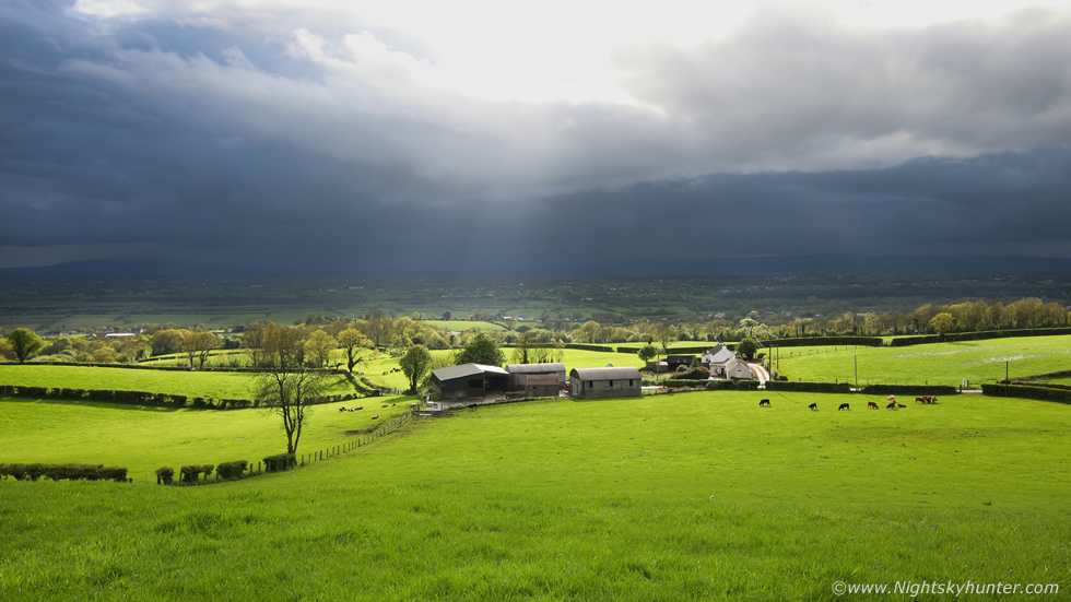
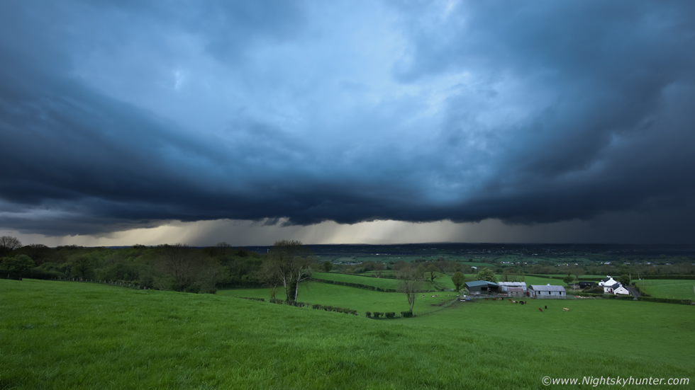
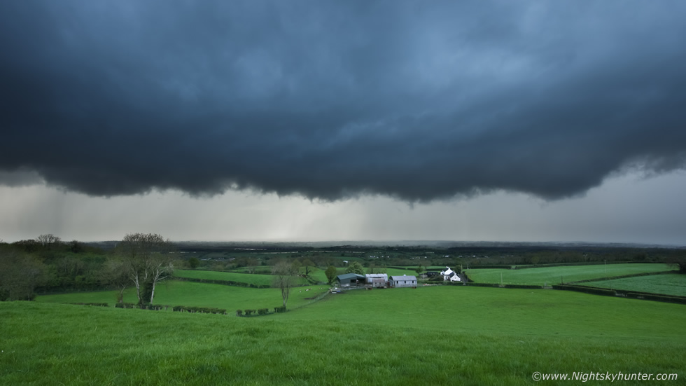
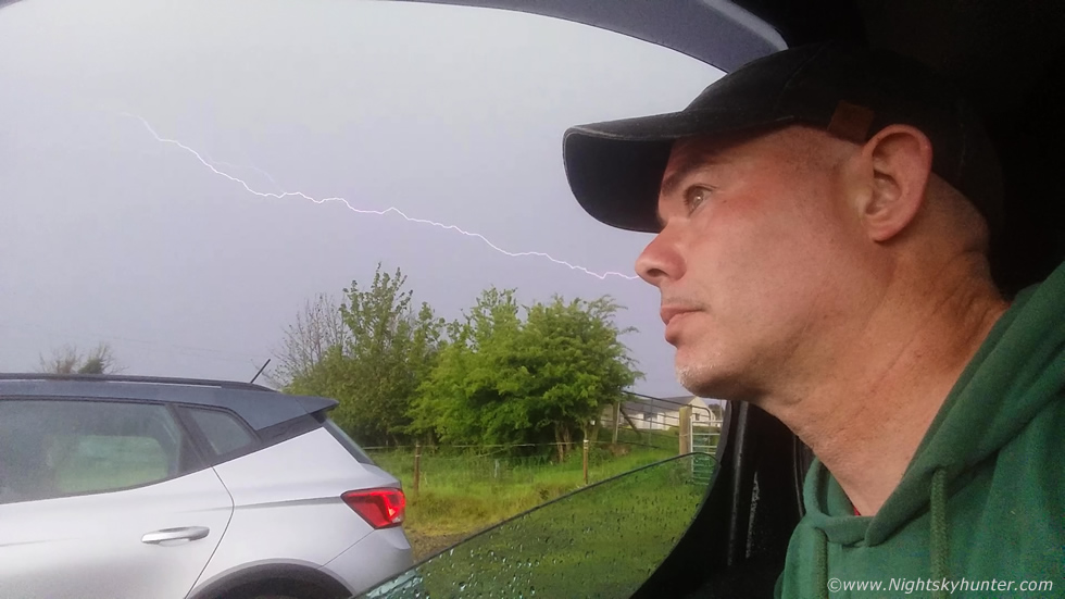
This was our spectacular view point, facing SW,W and NW across flat countryside looking down a steeply sloping hill across lush fields, this isolated farm house, and in the distance the Sperrins themselves. Crepuscular rays fanned through breaks in the cloud ahead of the developing thunderheads, everyone was shifting into combat mode, we knew we had a storm heading rite for us, you could cut the air with a knife, this was what we had been waiting for. As random rumbles broke the silence of the countryside we got our gear set up. I climbed over a gate into a field facing the farm and got the Canon 5D Mark IV ready with 15mm F/2.8 lens, I then got my settings selected and began shooting a time lapse video. While the camera clicked away I got the drone in the air and began taking still images and video sequences. Everyone else was doing the same, in fact, at one stage there were four drones in the air not to mention mobile phones and Nigel had set-up his DSLR with lightning trigger at the roadside with tripod at maximum height so the camera could see over the hedge. We were all in the zone and from here on I lost all track of time as I became lost in the moment, observing every aspect of the storm and checking camera settings.
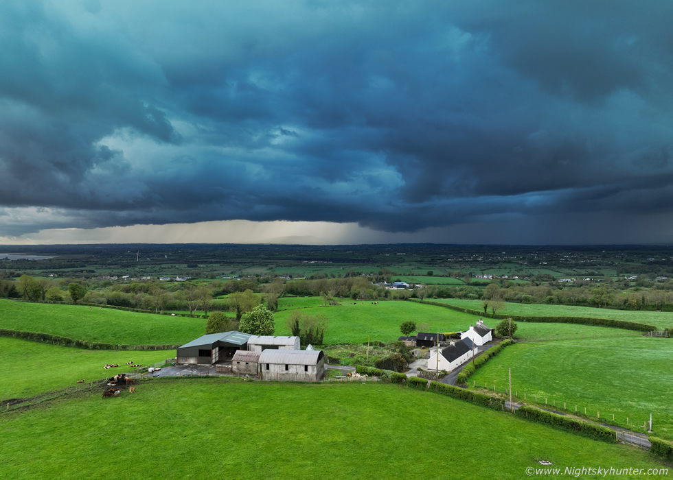 |
A little later we were in the company of a full blown multicell thunderstorm which on radar almost had squall line characteristics, from our vantage point the storm extended across a vast range of sky from the SW to NW. We could see three large precipitation cores on view however it was these two central cores which dominated the storm. The lighter core to the left (SW) was a new cell developing at a rapid pace, we could already hear thunder from it from unseen bolts likely high up within the updraught tower. We got a glimpse of the towers previous to this and we all agreed they looked very solid and impressive, it was clear the rapid cap break was convecting all that CAPE at once.
The core on the right was dropping c-g bolts into the fields, the thunder sounded different, before it was rumbles but now it was deep angry thunder, like an approaching predator. Every time we observed lightning and heard thunder we yelled with delight and every time a flash lit up the core Nigel's lightning trigger would fire the shutter, an amazing piece of equipment, like having our own lightning detector. What a location to watch a storm from, this is full wide angle using the four thirds sensor on the 20mp Mavic 3 Classic, the storm took on a very dark blue colour which contrasted beautifully with the green fields.
 |
The storm looked menacing as it approached this isolated farm house, the left core was now fully matured with a bowing gust front/shelf cloud becoming the main feature of the cluster. The c-gs were beautiful and from my own personal perception the bolts looked silvery-blue in colour and several looked electric blue to my eyes. The storm was almost on top of us at this stage, don't be fooled by the wide angle lens which makes things look further away, we still had drones in the air and cameras working as the storm crept closer and closer. It's easy to get fixated on the clouds, our cameras, and carried away by the thrill of the moment, however these same things can also generate tunnel vision when you become switched off to danger and to your surroundings.
I knew the bolts were getting closer and I was also aware of a large precipitation core off camera to our right which was closer than the others which looked to be coming in from our blind side as if the storm were throwing a left hook, I seen it, however I chose to stay a little longer. I was wondering what the others were thinking, I wasn't concerned yet and was prepared to stay out until it was almost on us however I also had to factor in the time it takes to grab the camera, climb over the gate, put the gear in the van, bring the drone down which was 80m high and 400m away and land it safely and pack it away and then get shelter in the inside, that all takes time and it's during those last moments that you are at the greatest risk. I did a mental calculation in my head on how long this process would take then continued shooting and flying. It was good fun watching the DSLR shoot time lapse while I recorded video with the drone trying to catch lightning, of course the best bolts happened outside my frame but the thrill of when and where the next one would strike sucked me in big time.
 |
DSLR image with 15mm wide angle lens on full frame, the storm looked intimidating now, the clouds were back and blue with a very heavy precipitation core sporting c-gs at all sides, from the right, middle, and far left. The bolts where hitting no more than half a mile away now, even the Cows were running for shelter. I really love this scene, I wish I had captured a c-g in my time lapse to compliment the image, I was shooting with a shutter of 1/15th of a second with lens stopped down to F/11 however the bolts must have struck between frames.
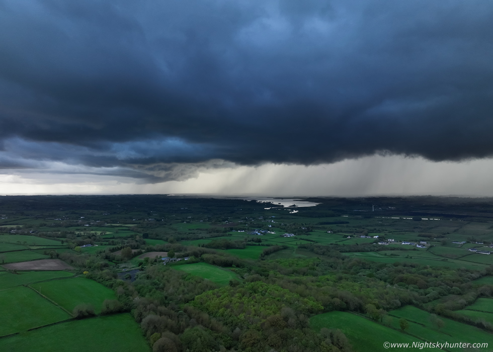 |
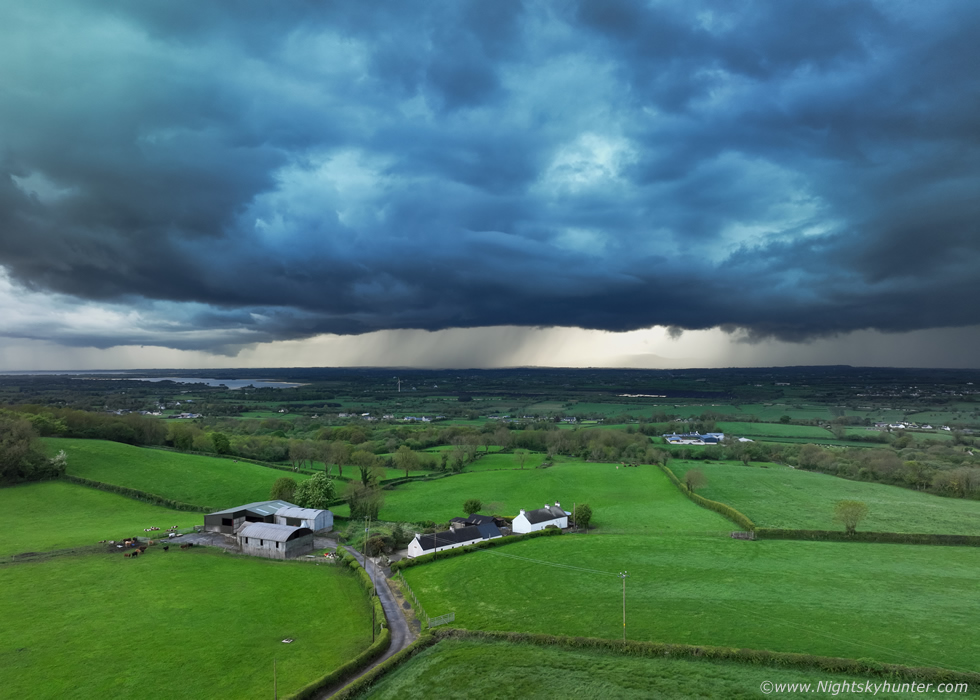
Drone view of the SW side of the line, I switched from auto mode to pro mode and manually dialed in the settings with the aperture at F/5. I wanted to capture the true darkness of the storm clouds. That's the upper region of Lough Neagh and Lough Beg in the distance, random c-gs where striking within the rain to the centre and right. It may not look like it on the image but the far left side had beautiful structure with complex undulations being under lit by filtered sunlight , I really should have shot that side with a 50mm lens however I didn't want to stop my time lapse. The radar revealed that this was the most intense storm in the entire country, Pecos Hank's advice had been bang on.
 |
This gives a better sense of how close to the core was, no wide angle lens, just the standard mobile phone FOV, I was recording a vlog in the field when the storm lit up accompanied by a big yell from everyone, I got it on the footage, this is a still from the video. Of course my phone's auto focus decided to shift at the wrong moment.
 |
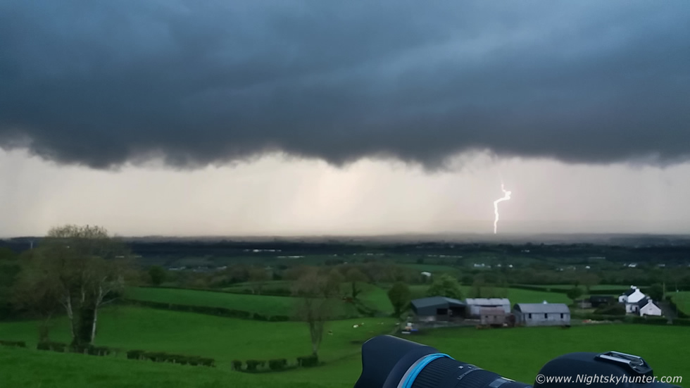
15mm wide angle DSLR image of the same scene, the thunder was a combination of anger and threats as if warning us of what was about to come, the entire storm was intensifying even more, it looked like our gamble had paid off, we waited for it to develop and move into this region with convergence and high ground which all aided with lift from the front. I was thinking if anyone else thought we should get ready to pack up, I said out loud ''we are in danger now'', but like myself no one wanted to move just yet. Then a big c-g struck the field to our half right, inside the very area in which we stood, the bolt took up a large area of sky, that core I had mentioned earlier had hooked us from the side and was looming rite over us, we where in serious danger now, Nigel said ''time to pack up guys'' and we did that as fast we could.
 |
The second we got inside our vehicles the core was on us with torrential rainfall hammering loudly on the roof with flashes of lightning and loud thunder, we were safe so I chilled out. I should have kept the the DSLR video on and my window mounted Go Pro too but I decided not to, I'm more of a cloud structure person anyway so I was already happy with what I got, now I could relax and just enjoy the storm visually, I regretted that decision. I was casually watching out the windscreen when suddenly two enormous blue cloud to ground bolts struck the ground within a second or two from each other. The first was rite in front of me filling the window and sky and the second was to my right, from my perspective it struck down rite beside Colleen's car. Instantaneous shot gun thunder followed, it was an awesome experience. Amazingly Colleen was recording footage live on facebook and managed to catch one of these bolts along with her reactions which made for a great video.
Those two bolts where rite on top of us and deadly, had we been outside our lives would have been seriously at risk. This was the closest lightning encounter we have experienced in years, even back to the Mullaghmore storms, in fact, this was the closet bolt since Paul Martin and I experienced a close strike which caused the power lines to sizzle and shake the car with thunder back on July 25th 2013 and of course the Lough Neagh night lightning of June 6th 2016 which was also vicious and close range. I used my phone to record a vlog with the camera facing towards me, I was hoping to get a bolt in the same frame as myself, I didn't have long to wait, this in-cloud bolt lashed across the sky, I got my lightning selfie, although I would have preferred a c-g.
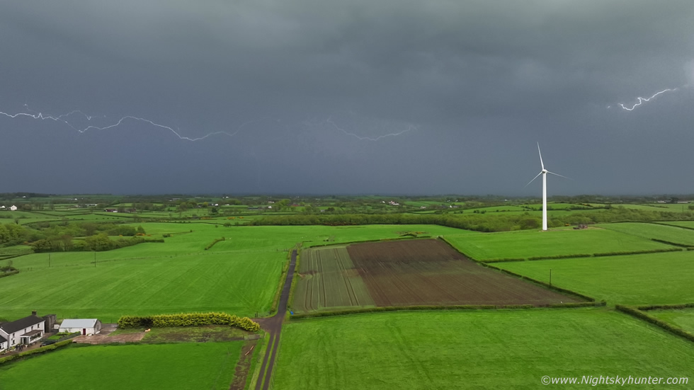 |
As the core cleared our position we got out to watch the back end of the storm which was still flashing away. There was a single wind turbine to our E, I said ''imagine the turbine got hit by lightning'', then just as I said that a huge crawler went across the sky beside the turbine which got more wows from us. Nigel raced to get his lightning trigger back in action, meanwhile Paul and Colleen got their drones in the air, I decided I may as well join in the action even though there was a small chance our drones could get hit by a rogue c-g. I let the drone hover and began recording video, it wasn't long before the first bolt was caught, a huge in-cloud which was so long it didn't fit inside the wide angle FOV.
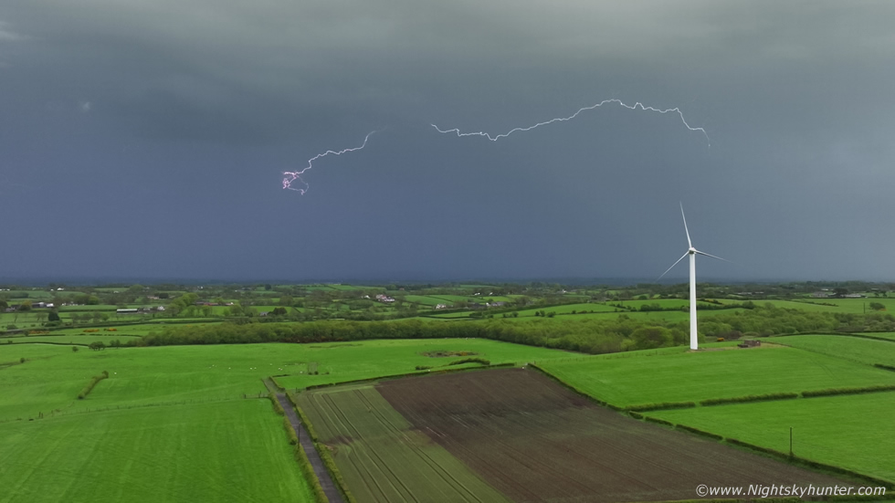 |
Then another, we got a good 15 min's or more of lightning action here before precipitation from mid level clouds moved in which forced us to land. We didn't mind, it had been a really good storm and a very memorable chase with almost all the team there to watch the action together which made this the most exciting and productive storm chase of the season so far. It was 20.00 and getting late so we all headed back to our homes feeling content, in fact, we were all buzzing for many days after.
Later we learned from Owain that the vast majority of c-gs were powerful positive bolts, in fact, news came in that two homes where damaged in this general area from lightning strikes, one house in particular suffered internal damage, blackened walls, smashed windows, fuses blown from the walls and a man was knocked to the floor. We also learned that a lady had captured a strongly distorted rope funnel cloud under this very same storm from Ballymena, the rope filled the mobile phone frame and the bottom was hidden by obstructions so we can't rule out this being a weak tornado, well done to her for getting the only image of a vortex event this day, proof that yet again this was a high caliber thunderstorm.
 |
During this period we had a week of convective outlooks making this the most active May in years. May 11th was one such day however the greatest chance of storms was below the border, however there was enough CAPE across central and southern N. Ireland for pulse storms. During the afternoon the sun came out which stirred many beautiful towering cumulus into life. The light was lovely and it seemed tower after tower was going up with nice plumes, of course I got lured out on a local chase, it was obvious the atmosphere was capped however due to the slack conditions funnels were possible.
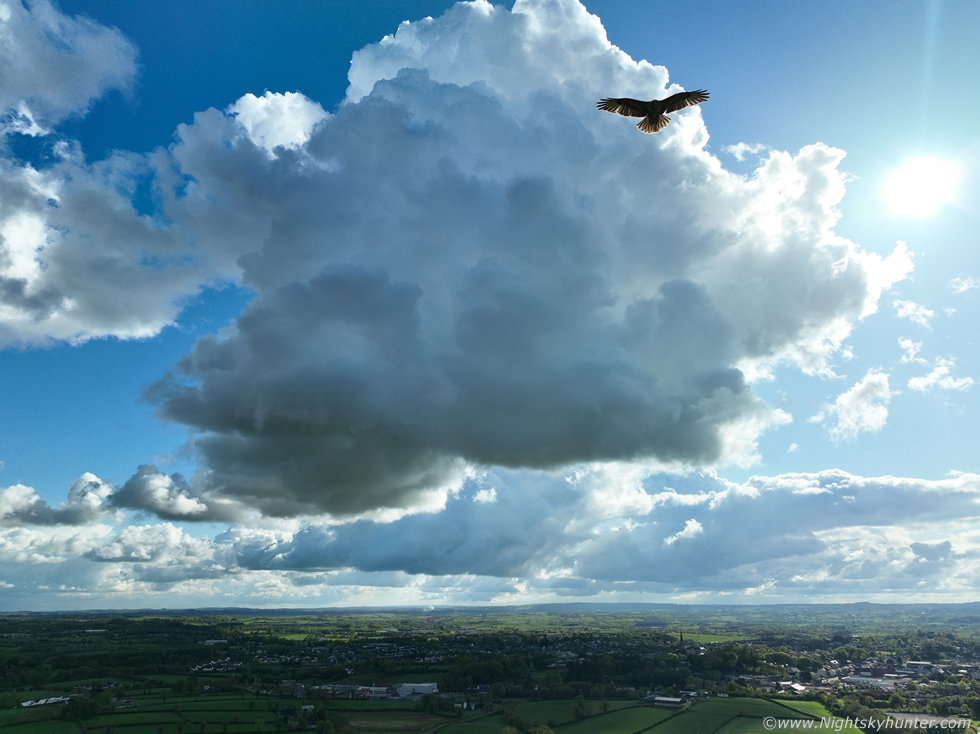
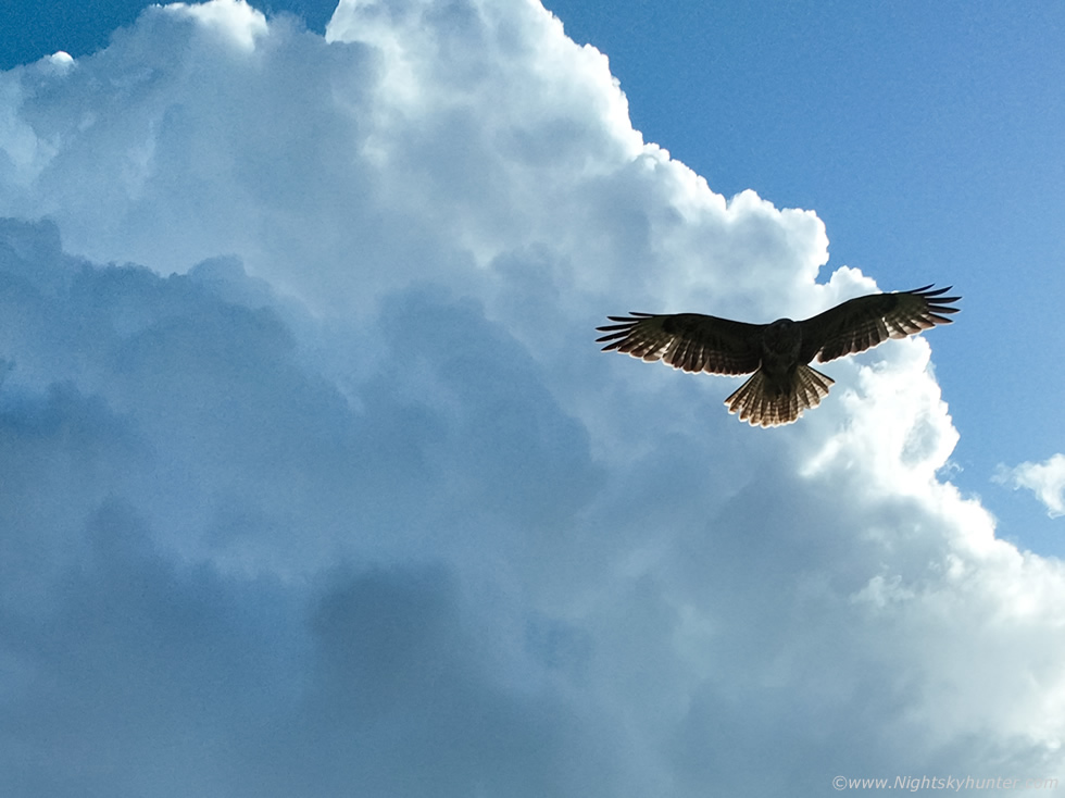
A newly forming updraught expanded vertically in real time, I got the drone in the air and began filming with the intention of getting B-roll for my end of year video, I switched to the drone camera then suddenly this Buzzard appeared from nowhere, two birds in the air, one man made one from nature, it felt like the Buzzard was inspecting the drone, I pressed the shutter and got this single image before it vanished.
 |
Deep crop, it was a fun encounter and a nice way to bring an active week to an end.
Footage of the May 8th storm with vlog, drone footage, DSLR time lapse, and a few bolts. Since this chase May has turned quiet once again with high pressure and currently no signs of instability on the models, however it's still early days. I'm hopeful we will get another good chase day soon however between chases I will also be monitoring the night sky for Noctilucent Clouds, this really is my favourite time of year. Thanks very much for reading.
Martin McKenna
